Before it grew into continents and archipelagos, this project began with cities, under the title 230 Imaginary Places to Escape. A couple of years ago I became interested in processes where clusters of rolled dice evolve into randomized entities according to groups of tables—basically, you roll eight dice of different values and follow a set of rules to determine what they mean in themselves and how the relate to one another. To the second, interrelational point, one key focus here is to outline how wealth, power, and allegiance are distributed around the city (I won’t get into it but it comes down to all the little crowns, dots, and crosses):
I’m pretty happy with the document I built to describe that process—I went so far as to illustrate it—but when I began the current phase that I call Meridian Dynasties, focusing on regions, I found the old city-oriented process under “230” was basically incompatible with the data the Meridian maps produced for cities and settlements. It’s been one of those things I’ve let sit in an indeterminate gray space until some future time when inspiration might strike and resolve the issue. And while I haven’t fully landed it, I think last week a new idea really took off that I’m excited about, as it’s moving in the direction of integrating the best parts of the previous 3-4 attempts.
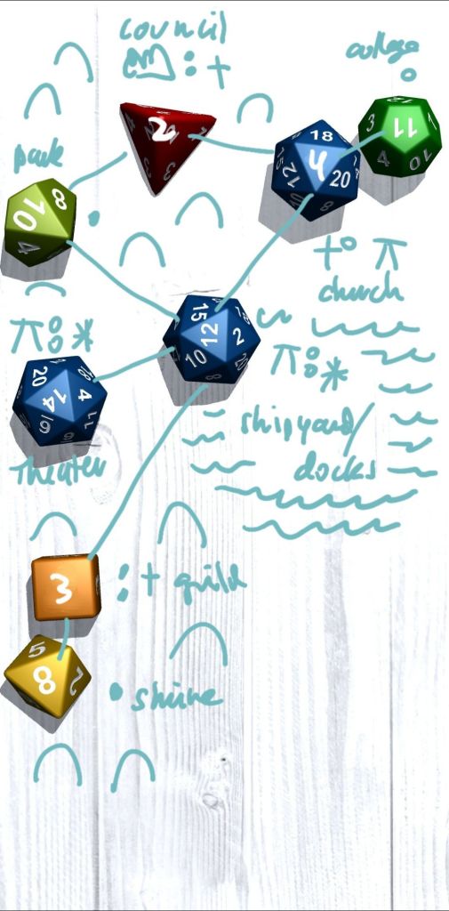
This version (call it 535 Imaginary Places if you have to call it something), reassigns the outputs from the original “230” tables so that they map more clearly onto the different colors of rings that result from the Meridians process. The roll itself has a bunch of dice that end up being erased, because not all rings occur in every city, and when they do occur they vary in number. Below is the reduced result of the same roll, including the ring-based template of the city as it might be seen on a Meridian map (lower left):
Each ring becomes two dice, which represent neighborhoods. For every additional ring you have of a certain type, you roll higher value dice for that pair of neighborhoods—so, here, you have 2d4 purple, orange, and blue dice for Esoteric, Commercial, and Affluent areas (these all have one ring), then 2d4+2d6 dice for Traditional communities (gray), and Wild spaces (green), since these have two rings each (there’s a sort of formula for Wild spaces that works differently than the rings but ultimately it amounts to the same thing). Higher die-values have the potential to result in more advanced neighborhood types of each variety, but the basic four are meant to be fundamental to the core identities of the rings they represent and occur with higher frequency.
Oops! Looking at the above and I’m seeing an orange d8 snuck in there from the starting roll—shouldn’t see those until we hit three rings and here Commercial’s at one. Let’s see if I took it out for the final step:
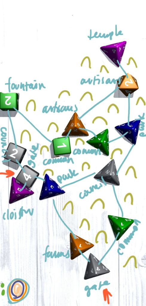
Nope! I must have just been flying through different rolls, that happens sometimes. In any case the extra Commercial neighborhood in here resulted in a “2” so it’s not entirely out of place with the level of commercial development there would otherwise be—just a few more artisans, next to another neighborhood of artisans, no less. Build it in and carry on. In any case, the process follows some of the same basic rules as Meridians—no more than three links per die, and links to similar values and colors are preferred when they don’t drastically limit the maximum number of links the city can contain.
This process still doesn’t do a couple of things I would like it to do. In “230” gates were tied to the d20s—as in, all the d20 neighborhoods essentially had a second sub-identity associated with a point of entry into the city located there. I’m not super chewed up about it being gone, as the gate identities were highly subjective, but I do miss the simplicity of just saying here’s where the gates are without a second thought. To be fair, the gray dice do have a neighborhood type called “gate” (two examples above in fact), but they don’t occur very frequently (and in theory they would, since “4” can be a result on any die, but of course that’s not a guarantee, otherwise why are we rolling dice). One thought I had was that all gray neighborhoods would be routes in and out of the city, but there’s also a result called “wall” and that would be incongruous.
I think the key here is to rethink what’s happening in the gray neighborhoods more generally. It might even make sense to move farms over from the Commercial list (again, orange dice) to the Traditional list (gray), although honestly that doesn’t really get at the problem here. It’ll take some thinking, is the short of it, and that will probably give a boost to more than just Traditional neighborhoods—Wild needs some help for sure; I don’t like “parks” in the Affluent neighborhoods; &c. &c. I’m also reminded that at one point I considered having gates at the most frequently-recurring number, I think the concern there is the result will feel too arbitrary (eg. “why are all points in and out of the city where the artisans live?”).
The other thing I’m not entirely happy with is that the output of this process is hard to translate into a “parchment” map, AKA “the fancy version.” I was really happy with the die-drop process I created between “230” and “535,” but it was a thing unto itself. It had nothing to do with the “230” or Meridian cities, and involved something like 50-60 dice, which made the erasing step I’m using in “535” a huge pain to implement. I loved drawing those maps though, because the buildings and their features corresponded directly the the dice and their results. Green d12 reads out a 7? Draw precisely two moderately-fancy single-family homes with chimneys and sheds. Gray d6 reads out a 4? Draw sixteen single-story rowhouses. Green d4 is a park (no special features), White d4 is a fountain with trees surrounding it equal to the roll readout, Blue are walls, Purple are churches, Red are castles, and so on. I’m trying to recycle as much of that all as I can, but I’m also just a bit rusty at the parchment maps and need to hit that groove again (which of course will be greatly helped once I establish a highly determined system—the rolls are random, the results are replicably programmed).
I will say this, though, the intermediate process still needed to produce bigger cities. I was on board with the feedback I got that the cities felt small. Partly I felt that was a minor problem, but also if I wanted to develop this into more of an explorable artifact it might fall a little flat—only so many neighborhoods to explore, only so many houses to explore in those neighborhoods, maybe too obvious. All things considered, I think we’re getting there! In fact I think I made strides a while back when I included some miniature “230” cities as marginalia on Meridian parchment maps, I should look at those again (and, bonus, try pulling out more of the building templates I used there).

Leave a comment